
What Is Chicamocha Canyon and Why Is It Unique?
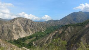
Located in the eastern cordillera of the Colombian Andes, crossing the departments of Santander and Boyacá, the Chicamocha Canyon is one of the largest canyons in South America, extending for approximately 227 kilometers along the Chicamocha River. In some areas, the canyon reaches depths of nearly 2,000 meters, particularly near the municipality of Los Santos, making it one of the most impressive landscapes of the Colombian Andes. Its slopes expose ancient geological formations that record more than a billion years of earth’s history, from the Precambrian Gneiss of Bucaramanga to younger Cretaceous limestones shaped by erosion and tectonic uplift.
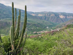
The Chicamocha Canyon is more than just geology; it is also a sanctuary of unique flora. On its arid slopes thrives the “ceiba barrigona” (Cavanillesia chicamochae), considered a natural symbol of the canyon. Sharing this harsh landscape are trees such as the olive tree and the castañete, along with the striking melocactus, small spherical cacti that dot the rocks under the blazing sun. Legumes and other resilient shrubs add shades of green and ocher to the rugged terrain, creating a mosaic of life adapted to the desertic environment. In total, botanists have recorded over 400 species of vascular plants, turning the Chicamocha Canyon into a true biodiversity refuge, where every plant is a proof of resilience in the face of an extreme and unique environment.
Understanding the Geology of Chicamocha Canyon
If you’re wondering how such a spectacular landscape formed, the answer lies in the interplay of erosion and tectonics in Colombia. Layers of sedimentary and metamorphic rocks expose ancient marine environments, mountain building processes, and the history of the Andean uplift and canyon formation. Joining a geological tour of Chicamocha Canyon lets visitors explore these formations, transforming each viewpoint into a window into deep geological time.
Geological evolution of Chicamocha Canyon:
The Chicamocha Canyon must be understood within the broader geological framework of the Eastern Cordillera of the Colombian Andes, a region with a geological record extending back over a billion years of continental development.
During the Precambrian, around 1.4 billion years ago, the basement rocks of the Santander Massif were formed. These rocks, today known as the Bucaramanga Gneiss, represent the metamorphosed remnants of early continental crust and mark one of the oldest records in the northern Andes. Their presence highlights the stability of ancient continental blocks that later became the foundation for successive tectonic and sedimentary processes.
In the Paleozoic and Mesozoic, this sector of the continent experienced repeated cycles of sedimentation, magmatism, and metamorphism, reflecting the opening and closing of oceanic basins and the assembly of continental blocks. Rock units such as the Silgará Schists, lutites of Bocas formation , Pescadero Granite, sandstones interbedded with siltstones of Jordán Formation and sandstones of Girón Formation were deposited during these intervals, recording a complex interplay between marine incursions, volcanic activity, and tectonic deformation.
A key stage happened in the Cretaceous Period (about 120 million years ago), when a major marine transgression flooded large areas of the present day in the Eastern Cordillera. Shallow epicontinental seas spread across northern South America, leading to the deposition of extensive limestones and rich carbonate sediments. These marine environments also preserved abundant fossils including ammonites, gasteropods, bivalves, benthic foraminifer, in some particular cases also it has been found some reptiles as turtles (Notoemys zapatocaensis), its name is due to the place where those were found in Santander, whose remains in the Rosablanca and Paja formations are the proof of the ancient biological richness. The rocks in this period being highly soluble, became especially susceptible to chemical weathering and erosion. Their later exposure would play a critical role in the sculpting of the Chicamocha Canyon.
With the onset of the Andean orogeny during the Cenozoic (65 million years ago to the present), the subduction of the Nazca Plate and Caribbean Plate beneath the South American Plate generated intense crustal compression, uplift, and faulting. In this context, the Bucaramanga Fault System became a dominant structural feature, shaping the orientation of the canyon and controlling much of its geomorphological evolution.
Finally, within this tectonic framework, the Chicamocha River began to incise the uplifted and fractured terrain. Over the past 30 million years, continuous fluvial erosion, mechanical weathering, and chemical alteration sculpted one of the deepest canyons in South America. The oxidation of iron bearing minerals further enhanced the reddish tones of its slopes, producing the canyon’s distinctive visual character.
Today, the Chicamocha Canyon, stretching 227 kilometers in length and reaching depths of nearly 2,000 meters near Los Santos, is not only one of the most spectacular landscapes of Colombia but also a natural record of Precambrian crustal evolution, Mesozoic marine transgressions, and Cenozoic Andean tectonics. It stands as a living geological archive, where more than a billion years of earth’s history are written in rocks.
Why Choose an Educational Tour Over a Regular Tour?
While a standard trip focuses only on landscapes, an educational tour in Colombia adds layers of meaning. Imagine walking along the canyon while understanding how Colombian geology tours connect to the rise of the Andes. With GeoTours of the Americas, your experience becomes both adventurous and educational. Its vast cliffs and exposed rock formations reveal more than a billion years of earth’s history, offering a unique opportunity to see firsthand how tectonics, erosion, and river incision have sculpted one of the most impressive landscapes of the Colombian Andes. With GeoTours of the Americas, you’ll explore stratigraphic sequences, ancient marine limestones, and the structural features controlled by the Bucaramanga Fault, all in a safe, guided setting.
In contrast to standard tours, GeoTours of the Americas is directed by highly qualified professionals. Francisco Velandia, M.Sc. in Geological Sciences and Ph.D. in Geosciences, brings expertise in structural geology, neotectonics, geomorphology, and geological heritage. Luis Carlos Mantilla Figueroa, M.Sc. in Mineralogical Sciences and Ph.D. in Geological Sciences, contributes his specialization in igneous petrology, mineral deposits, and geological mapping. Together, they will guide you through the canyon’s fascinating history, explaining how Precambrian basement rocks, Cretaceous sediments, and millions of years of fluvial erosion combined to form this natural wonder. Along the way, you’ll enjoy breathtaking viewpoints, cultural heritage insights from the Guane civilization, and a deep understanding of Colombian geology.
Planning Your Canyon Adventure in Colombia
The Chicamocha Canyon Colombia experience is easily accessible from Bucaramanga and San Gil, two cities well connected by air and land. A guided geology tour of Colombia includes transportation, expert guidance, and activities tailored to different levels. Whether you’re traveling solo, with friends, or as a family, this canyon tour of South America offers safety, learning, and adventure all in one.