What Is Nevado del Ruiz and Why Is It So Famous?
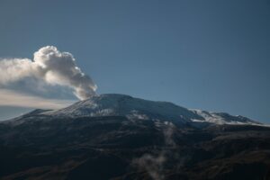
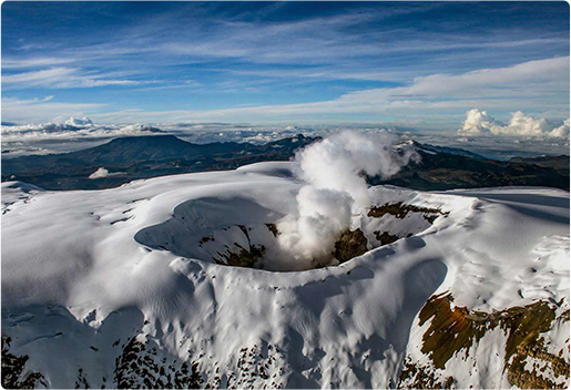
Located in the Central Cordillera of Colombia, near the departments of Caldas and Tolima, the Nevado del Ruiz volcanic complex consists of a series of volcanic structures and deposits that reflect the evolution and development of the Nevado del Ruiz. This volcanic body reaches an elevation of 5,321 meters above sea level. At its summit lies the Arenas Crater, with a diameter of 750 meters and a depth of 200 meters, covered by a glacier spanning 9.3 km 2.
For the indigenous Quimbaya civilization, the Nevado del Ruiz was known as Cumanday, meaning ‘beautiful white’, inspired by the snow that blankets its summit. After the arrival of the Spanish, it was renamed Nevado del Ruiz, in honor of Alfonso Ruiz de Sahajosa, one of the first people to create cartographic sketches of the area for colonial land grants.
In addition to its geological significance, the Nevado del Ruiz volcano is also remembered for the tragic eruption on November 13, 1985. This event triggered massive lahars that claimed the lives of approximately 25,000 people in two nearby towns. In Chinchiná, located in the department of Caldas, the high speed of the flow was a key factor in the devastation. Meanwhile, the town of Armero in the department of Tolima was completely buried under the lahar, resulting in one of the deadliest volcanic disasters in history.
Since then, this event is an example for studying lahars around the world, the volcano has been closely monitored and extensively studied by institutions such as the Colombian Geological Survey by the subdivision of Volcanological and Seismological Observatory of Manizales.
The current landscape of Nevado del Ruiz is the result of hydrothermal processes, combined with millions of years of volcanic activity. For travelers interested in science, geology, and meaningful adventure, it offers an unforgettable experience where natural beauty and earth science come together.
Understanding the Geology of Nevado del Ruiz
The Nevado del Ruiz volcano is located in the northern part of the Andean volcanic belt, a region that corresponds tectonically to the subduction of the Nazca Plate beneath the South American Plate. As a result, a very narrow volcanic arc is formed, with a dip angle reaching approximately 45 degrees.
This tectonic interaction also generates a zone of combined compressional and shear movements, leading to the formation of new faults and regional structures as the Palestina fault, the fault system of Romeral and the Ibague fault. These main structures are the result of the deformation caused by subduction and allow the flow of magma, which is also why the Cerro Bravo and Ruiz volcanoes are aligned with the Palestine fault.
The volcanism generated at the Nevado del Ruiz Complex is primarily andesitic to dacitic. Regarding its geological record, the Nevado del Ruiz Volcano is estimated to be about 2 million of years old since the first formation of Ruiz known as Ancestral Ruiz, it has been classified as an explosive and effusive volcano with explosive vulcanian and subplinian eruptions.
Geological context of the Nevado del Ruiz
The Nevado del Ruiz is not only impressive due to its snow capped summit, but also for the richness and complexity of its geological history, this volcano has been built over the Cajamarca Complex. In this area, we find metamorphic rocks, including schists, muscovite, chlorite, phyllites, and quartzites. These rocks are evidence of ancient tectonic processes and extreme conditions that deeply transformed their original composition.
Nearby here are also intrusive igneous bodies, such as the Manizales Stock (formed by quartz diorite and tonalite), estimated to be 56 to 57 million years old, and the El Bosque Batholith, composed of granodiorites dating back approximately 49 million years.
Geological evolution:
The Nevado del Ruiz volcano has gone through four major stages of development over time.
The first stage, known as the Pre-Ruiz period, took place over 1.033 million years ago. During this time, thick lava flows made of a volcanic rock called andesite were released in the area north of where the volcano stands today. These flows were laid down in solid layers, some up to 30 meters thick. They covered older rock formations and marked a long pause before the volcano’s next phase of activity.
The second stage, called the First Eruptive Period, had both constructive and destructive phases. In the constructive phase, more lava flowed out, spreading across about 120 square kilometers. Then came the destructive phase, marked by massive landslides known as the El Líbano avalanches, which buried large areas to the east of the volcano. Around this time, volcanic mudflows known as lahars began to form, especially in the Chinchiná River basin.
The third stage, the Intermediate Eruptive Period, began after the collapse of the older volcanic structure. The La Olleta volcano continued to grow, developing a cone shape with a crater and a landslide scar on one side. Several small volcanic centers also appeared nearby, including the Nereidas and Piraña volcanoes. These released lava and ash, often through small eruptions and dome collapses. Other lava domes in the area partially collapsed as well, sending down hot mixtures of ash and rock.
The final stage, called the Second Eruptive Period, saw the formation of the modern Nevado del Ruiz. It began with quiet lava flows spreading outward from the center. These flows, made of andesitic lava rich in minerals like pyroxene and amphibole, occurred between 66,000 and 26,000 years ago. Later, the volcano experienced periods of explosive eruptions, producing clouds of ash and fast-moving flows of hot gases and debris. These explosive events were especially intense in the valleys of the Nereidas, Molinos, and Gualí rivers. In many cases, the heat from eruptions melted snow and glaciers on the volcano, triggering large and dangerous lahars.
Why Visit Nevado del Ruiz with Geotours of the Américas?
For geology enthusiasts and curious travelers alike, Nevado del Ruiz is a living classroom. Its activity offers a singular chance to see firsthand how magma, and ice interact to create spectacular natural events. With GeoTours of the Américas, you’ll explore volcanic formations, glacial valleys, and learn about volcanic hazards in a safe, guided setting.
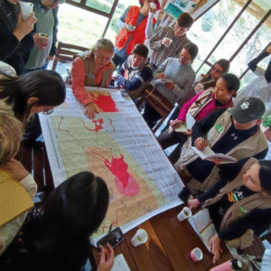
Unlike standard tours, GeoTours of the Americas is guided by Dr. Dayana Shonwalder and Dr. Angélica Álvarez, professors and researchers in vulcanology, geochemistry, structural geology, and tectonics, they will take you through the volcano’s fascinating history, including lessons from the devastating 1985 eruption, while showing you the incredible beauty of the Andean highlands. Whether you’re a student, a professional geologist, or just someone who loves nature and adventure, a trip to Nevado del Ruiz with us will leave you inspired and informed.
What to Expect on a Nevado del Ruiz Volcano Tour
On a Nevado del Ruiz volcano tour with GeoTours of the Américas, you’ll hike through glacial valleys, volcanic slopes, and unique geological formations before reaching key viewpoints of the Arenas Crater. Stops include the Volcanic Observatory, where you’ll learn how experts monitor the volcano’s activity and volcanic hazards. Our guided geology tour is led by Dr. Dayana Shonwalder and Dr. Angélica Álvarez, who share scientific insights into the region’s tectonics, past eruptions, and glacial history. Travelers leave with a deeper understanding of how magma, ice, and time have shaped this extraordinary landscape.
Why Choose an Educational Tour Over a Regular Tour?
While a standard sightseeing trip offers views, our educational tours in Colombia deliver context. You’ll gain real scientific knowledge in the field — perfect for students, families, and curious travelers. We combine science-based tourism with breathtaking scenery, making your visit both memorable and meaningful.
Planning Your Volcano Adventure in Colombia
For volcano hiking in Colombia, come prepared for high altitude. We recommend layered clothing, sun protection, sturdy hiking boots, and a light daypack. A moderate fitness level is needed, and we’ll provide guidance to help you acclimate so you can enjoy your adventure travel in Colombia safely.